 The ride down we stopped at a few scenic views. After the second stop (about 3.1 miles from the top, counting as "CS" mode), the car restarted in EV mode
with 3 miles of EV. Road down in L, though I ahd to use the brake a bit as it would not hold at 25mph in L and some of the turns are very very sharp.
At the brake check station, the Volt brakes were 74F (Ambient temp was mid 60's).. the park ranger asked questions how it worked.
We arrived back at the highway with 39miles of EV range with a max regen SOC of 73.72 or about 83% of the usable battery
was regenerated!
The ride down we stopped at a few scenic views. After the second stop (about 3.1 miles from the top, counting as "CS" mode), the car restarted in EV mode
with 3 miles of EV. Road down in L, though I ahd to use the brake a bit as it would not hold at 25mph in L and some of the turns are very very sharp.
At the brake check station, the Volt brakes were 74F (Ambient temp was mid 60's).. the park ranger asked questions how it worked.
We arrived back at the highway with 39miles of EV range with a max regen SOC of 73.72 or about 83% of the usable battery
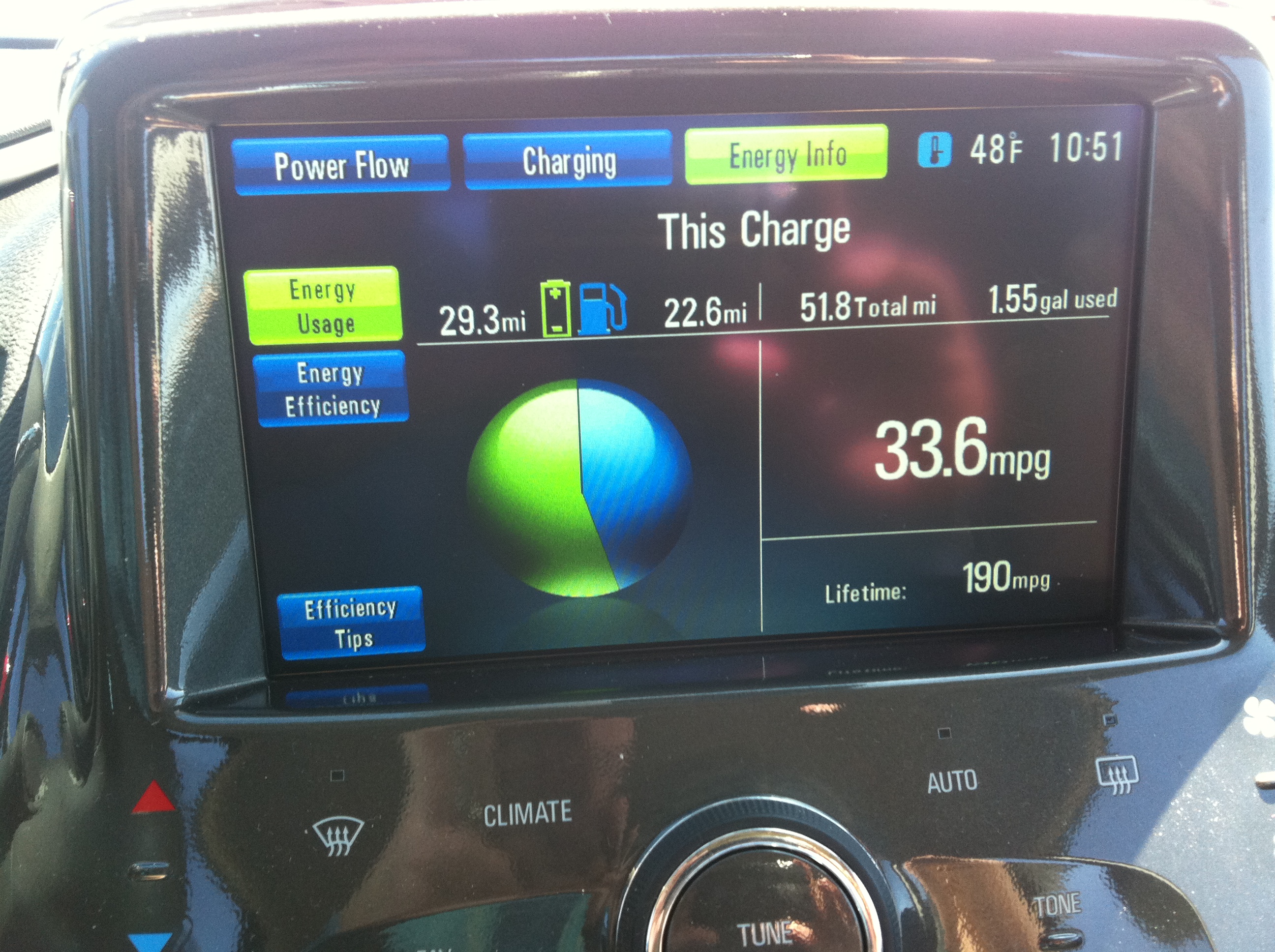
was regenerated!  I arrived home with 81.1 miles EV, 25.7 CS using 1.62 gallons.
The regen energy was, of course, really from gas energy. If the car had sayed in CS mode on the return trip, it would have been 51.8 more CS miles for a
total of 77.5 miles on 1.62 gallons or 47.83 MPG. But then it would have included the power from 10 miles of EV range
left when mountain mode started the ICE. Accounting or the MM battery buffer, I would say it was 39.3miles of EV (which
included a serious elevation gain) and 67.5 miles of CS, or 41.6MPG climbing one of the roughest roads in the US. But
my voltstats will bear the hurt of <15MPG only uphill.
I arrived home with 81.1 miles EV, 25.7 CS using 1.62 gallons.
The regen energy was, of course, really from gas energy. If the car had sayed in CS mode on the return trip, it would have been 51.8 more CS miles for a
total of 77.5 miles on 1.62 gallons or 47.83 MPG. But then it would have included the power from 10 miles of EV range
left when mountain mode started the ICE. Accounting or the MM battery buffer, I would say it was 39.3miles of EV (which
included a serious elevation gain) and 67.5 miles of CS, or 41.6MPG climbing one of the roughest roads in the US. But
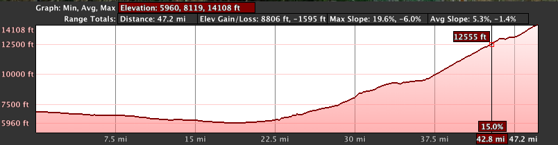
my voltstats will bear the hurt of <15MPG only uphill.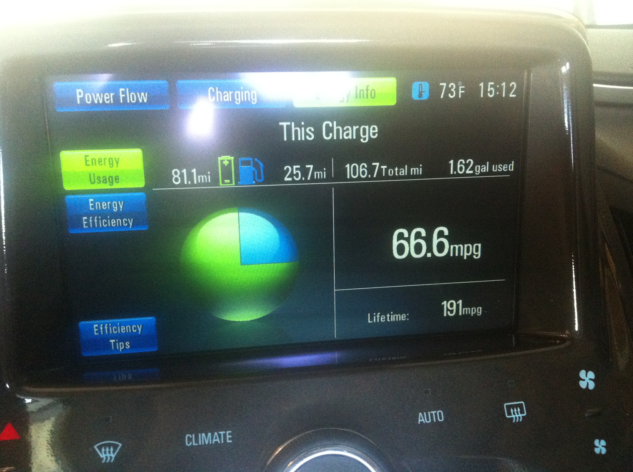 Here is the approximate elevation map for the trip to the peak (minor differences as I had to pick some folks up). Note the average overall 47 miles is 5.3% grade, and the max slope was 19.6% grade with multiple sections > 15% grade. It is steap!